Click for page with larger image
Getting the lay of the land (and water)
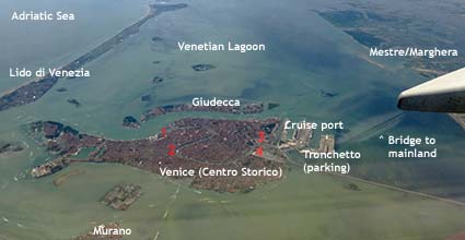
Venice's centro storico, or historic center, is a compact and walkable city of about 60,000 people on 118 tiny islands connected by 425 footbridges.
In the aerial photo above, you can see labels for:
- Adriatic Sea (top left), a branch of the Mediterranean.
- Lido di Venezia, a long, narrow resort island that protects the Venetian Lagoon from the Adriatic.
- The Venetian Lagoon, a shallow mixture of fresh water and sea water that is bathed by twice-daily tides from the Adriatic.
- Giudecca, an island just north of Venice's historic center.
- Venice (Centro Storico), the main part of the city.
- The cruise port, which has two parts: Marittima and San Basilio.
- Tronchetto, a parking island for cars and buses.
- The Ponte della Libertà, or bridge to the mainland, which carries both trains and cars.
- The mainland districts of Mestre and Marghera.
- Murano (bottom of photo), Venice's glassmaking island.
You'll also see four landmarks numbered in red:
- Piazza San Marco (upper left numeral).
- Rialto Bridge (lower left numeral).
- Piazzale Roma (upper right numeral), Venice's gateway for city buses, airport buses, and taxicabs.
- Venezia Santa Lucia Railroad Station (lower right numeral).
Airport locations:
- Venice Marco Polo Airport is a few kilometers north of Mestre, on the Italian mainland.
- Treviso Airport, used by Ryanair and several other budget carriers, is on the Italian mainland about 40 km or 25 miles from Venice.